NCEDC News/Blog
2015 wildfires take a toll on seismic monitoring
Categories: Data Center Outages | USGS Northern California Seismic Network (NCSN) | Calpine/LBL Geysers data (BG) | 2015 wildfires | The Geysers | Earthquake Catalogue | Catalogs
October 1, 2015
 |
|
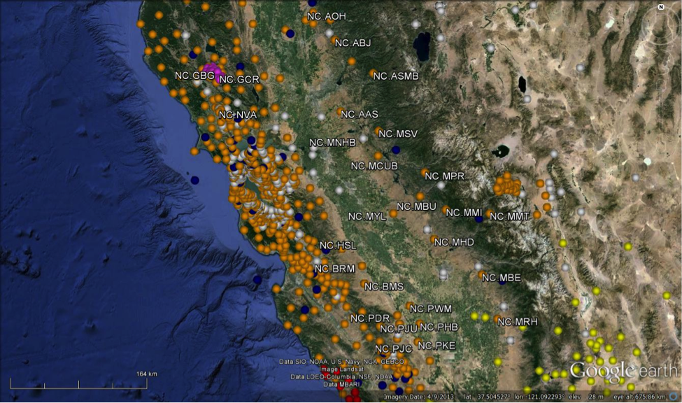
| Figure 1: Map of stations in Northern and Central California, including NC (orange), BK (blue), CI (yellow), NP (white), and BG (pink). Not all stations of the California Integrated Seismic Network are shown. The labelled stations are the USGS that have been affected by the 2015 wildfire season as of Oct 1, 2015; a number of stations were damaged and communications were disrupted in the BG network as well. (Click to view larger.) |
In a typical year, the USGS might lose one or two seismic stations in Northern and Central California from wildfire damage. Thus far in 2015, over 30 stations operated by the USGS have been affected and an additional 30 maintained by Lawrence Berkeley National Lab in the Geysers have been affected (Figure 1). This loss of monitoring sites has had an impact on the operations of the Northern California Seismic System (NCSS), particularly in the detection and location of small events in the southern Central Valley and the Geysers area.
On September 11, 2015 at 09:30 UTC, the Butte fire damaged the Sierra Vista microwave communications link. This microwave link is responsible for bringing in 23 NCSN (Northern California Seismic Network) stations in the San Joaquin Valley. As a result, we are no longer receiving data from AAS, ABJ, AOH, ASMB, BMS, BRM, HSL, MBE, MBU, MCUB, MHD, MMI, MMT, MNHB, MPR, MRH, MSV, MYL, PAR, PDR, PHB, PJC, PJU, PKE, and PWM. These stations provide coverage in the Sierra Foothills and in the western foothills of the San Joaquin Valley. USGS Menlo Park staff visited the site with personnel from the Army Corps of Engineers (ACOE) on September 21st. We are working with ACOE to restore the link but currently do not have an estimated time for its return to operation. The loss of these stations has reduced the sensitivity of the NCSS for the detection and location of small events, as well as degrading location accuracy. The change is largest in the valley, west and slightly south of Mammoth, of ~0.7-0.8 magnitude units. This calculation was done by Corinne Bachmann, of LBNL, who studied NCSS catalog completeness as part of her Ph.D. in 2009. The new threshold is magnitude ~2.3.
  |
|
|
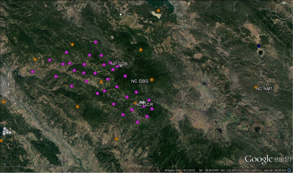
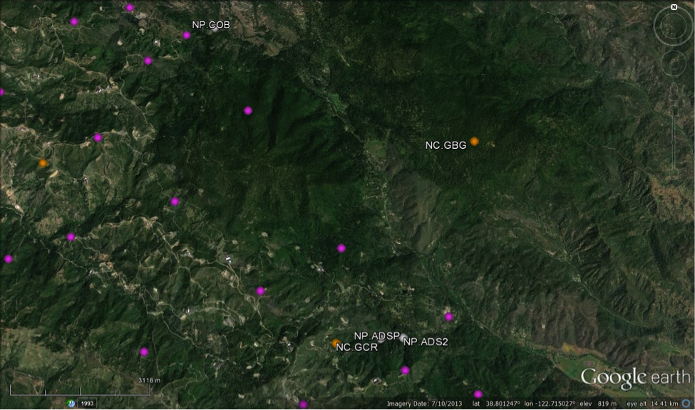
Figure 2. Top is a broadscale view of the stations in the greater Geysers area; bottom is a close up showing the locations of the damaged or unknown status stations in the NC and NP networks. Pink stations are those in the BG network, which are not currently being received in real-time monitoring system. (Click to view larger.) |
In parallel, the Valley fire has affected our monitoring in the Geysers area. Beginning on September 13, 2015, we began to lose contact with stations NC.GBG, NC.GCR, NP.COB, NP.ADSP, and NP.ADS2 (Figure 2). We were able to access these sites on September 28th to assess damage. Station NC.GBG was restored on the 28th and NC.GCR was restored on the 29th. Station NP.ADSP has been destroyed. NP.ADS2 is in a building which is still standing but without power or communications. The status of NP.COB is still unknown.
 |
|
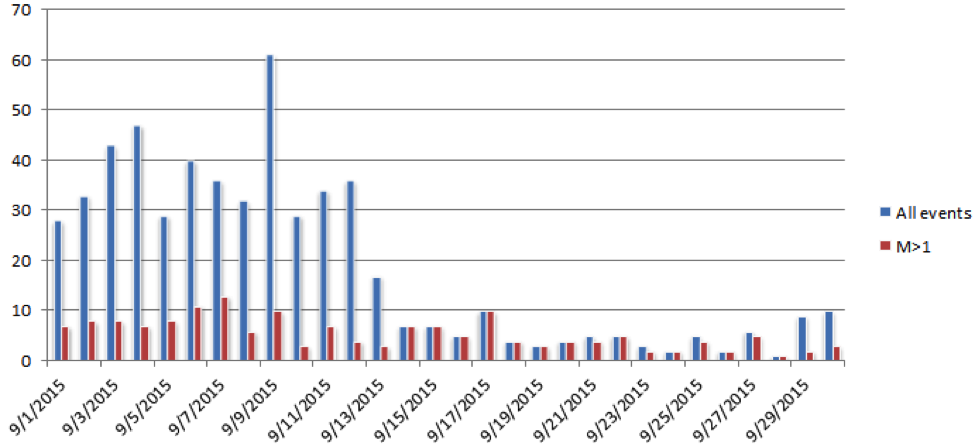
| Figure 3: Number of events per day in the Geysers polygon. Blue is the count of all earthquakes; red is the count of events of magnitude 1 and higher. While this figure illustrates the variability in the number of events per day, the sudden decrease on Sept 13th is associated with the loss of the NCSN stations GBG and GCR and the BG network. (Click to view larger.) |
We will provide status updates as more information becomes available.
The loss of data from the BG network, combined with the temporary loss of GBG and GCR has significantly lowered the number of events detected and located in the Geysers, as illustrated in Figure 3, which shows the number of events per day in the NCSS Geysers polygon for the month of September.
In addition to the damage to the NCSN and NSMN (National Strong Motion Network) sites, the NCSS lost contact with the stations in the BG network, operated by Lawrence Berkeley National Lab, on Sept 13th at 0955 UTC. This network of ~30 highly sensitive stations, installed as part of the Enhanced Geothermal Systems project, facilitates the location of small events in the Geysers area below magnitude 1.2. LBNL staff are working to restore stations and revive the communications links. As of Oct 1, 20 stations are being recorded and stored on a local computer.
Finally, two other NCSN stations have been damaged or destroyed in other fires this year - NC.NMT to the Jerusalem Fire and NC.NVA to the Wragg fire. We plan to rebuild NC.NMT in the coming weeks and are assessing our options for NC.NVA.
NCEDC News
-
: Entire NCEDC Dataset Now Available Through AWS
-
: Current issue with ObsPy FDSN web service client
-
: FTP service to be retired on May 31, 2022
Categories
- 2003 San Simeon Earthquake (5)
- 2004 Parkfield Earthquake (3)
- Berkeley Digital Seismic Network (BDSN, BK) (11)
- Bugs (6)
- Calpine/LBL Geysers data (BG) (8)
- Catalogs (21)
- Data Access Methods (19)
- Data Availability (32)
- Data Center Operations (26)
- Data Center Outages (9)
- Data Distribution (3)
- Data Holdings (16)
- Earthquake Catalogue (21)
- Earthquake Depths (3)
- Earthquake Locations (9)
- High Resolution Seismic Network (HRSN, BP) (4)
- Magnitude (10)
- Magnitude Errors (4)
- Metadata (4)
- Northern California Earthquake Data Center (NCEDC) (14)
- Northern California Seismic System (NCSS) (7)
- Northern Hayward Fault Network (NHFN, BK) (3)
- SEED format (6)
- Sampling Rate (3)
- Strain Data (3)
- The Geysers (5)
- Timing Errors (3)
- U.S. Geological Survey (USGS) (3)
- UC Berkeley Seismological Laboratory (BSL) (4)
- USGS Northern California Seismic Network (NCSN) (11)
- Uncategorized (4)
- Waveform Data (33)
- Web Services (5)